http://linked.data.gov.au/def/placenames
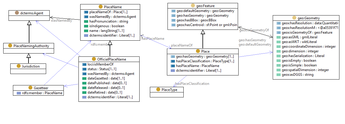
Place Names is an RDF/OWL Ontology to define the structure and relationship of the names of geospatial features (locations).
A place-name is a text string in a specified language that is
An official-place-name is a place-name that also
Each individual place-name or official-place-name is associated with one place.
A place is
This ontology uses classes and properties from existing vocabularies, in particular

| IRI | http://linked.data.gov.au/def/loci#Dataset |
|---|---|
| Sub-classes |
Gazetteerc |
| IRI | http://linked.data.gov.au/def/placenames/Gazetteer |
|---|---|
| Description |
A Gazetteer is a list of Place Names |
| Super-classes |
loci:Datasetc |
| Restrictions |
rdfs:member only PlaceNamec |
| IRI | http://linked.data.gov.au/def/placenames/Jurisdiction |
|---|---|
| Description |
Local, State, Territory or National (Commonwealth) Government that has authority to formally establish (i.e. gazette) place names within its jurisdictional area. |
| Super-classes |
PlaceNamingAuthorityc |
| IRI | http://linked.data.gov.au/def/placenames/OfficialPlaceName |
|---|---|
| Description |
The name of a place, assigned by an official naming authority and included in the Place Names Gazetteer of Australia. |
| Example |
ex:Ayers-Rock
rdf:type :PlaceName ;
rdf:type :OfficialPlaceName ;
loci:isMemberOf <https://www.ntlis.nt.gov.au/placenames/> ;
:dateGazetted "1850-01-01"^^xsd:date ;
:dateRetired "1989-12-31"^^xsd:date ;
:name "Ayers Rock"@en-AU ;
:placeNameOf ex:NT_10532 ;
:status :retired ;
:wasNamedBy <https://www.ntlis.nt.gov.au/placenames/> ;
rdfs:label "Ayers Rock"@en ;
.
ex:Ayers-Rock-Uluru
rdf:type :PlaceName ;
rdf:type :OfficialPlaceName ;
loci:isMemberOf <https://www.ntlis.nt.gov.au/placenames/> ;
:dateGazetted "1990-01-01"^^xsd:date ;
:dateRetired "2005-12-31"^^xsd:date ;
:name "Ayers Rock / Uluru"@en-AU ;
:placeNameOf ex:NT_10532 ;
:status :retired ;
:wasNamedBy <https://www.ntlis.nt.gov.au/placenames/> ;
rdfs:label "Ayers Rock / Uluru" ;
.
ex:Uluru-Ayers-Rock
rdf:type :PlaceName ;
rdf:type :OfficialPlaceName ;
loci:isMemberOf <https://www.ntlis.nt.gov.au/placenames/> ;
:dateGazetted "2006-01-01"^^xsd:date ;
:isIndigenous true ;
:name "Uluru / Ayers Rock"@pjt ;
:placeNameOf ex:NT_10532 ;
:status :gazetted ;
:wasNamedBy <https://www.ntlis.nt.gov.au/placenames/> ;
rdfs:label "Uluru / Ayers Rock" ;
.
|
| Super-classes |
() PlaceNamec |
| Restrictions |
dcterms:identifier some ID-GAZc dateReleaseddp max 1 loci:isMemberOfop some Gazetteerc dateGazetteddp exactly 1 dcterms:identifier some ID-AUTHc datePublisheddp max 1 statusop exactly 1 dateRetireddp max 1 wasNamedByop some PlaceNamingAuthorityc |
| In domain of |
datePublisheddp dateReleaseddp dateGazetteddp dateRetireddp |
| IRI | http://linked.data.gov.au/def/placenames/Place |
|---|---|
| Description |
An identifiable geographic Place as defined by the Composite Gazetteer of Australia. A Place is classified according to an extensible set of types. |
| Example |
ex:NT_10532
rdf:type :Place , geo:Feature ;
:hasPlaceClassification <http://pid.geoscience.gov.au/def/voc/ga/PlaceType/MOUNTAIN> ;
:hasPlaceName ex:Ayers-Rock ;
:hasPlaceName ex:Ayers-Rock-Uluru ;
:hasPlaceName ex:Uluru-Ayers-Rock ;
dcterms:identifier "10532"^^:ID-AUTH ;
dcterms:identifier "NT_10532"^^:ID-GAZ ;
geo:hasGeometry [
rdf:type <http://linked.data.gov.au/def/auspix#Geometry> ;
geox:asDGGS "R7430551"^^geox:dggsLiteral ;
rdfs:seeAlso <http://ec2-52-63-73-113.ap-southeast-2.compute.amazonaws.com/AusPIX-DGGS-dataset/ausPIX/R7430551> ;
] ;
geo:hasGeometry [
rdf:type sf:Point ;
geo:asWKT "POINT(-25.3415 131.0354)"^^geo:wktLiteral ;
] ;
rdfs:seeAlso <http://ec2-52-63-73-113.ap-southeast-2.compute.amazonaws.com/placenames-dataset/placename/NT_10532> ;
.
|
| Super-classes |
geo:Featurec |
| Restrictions |
dcterms:identifier min 1 geo:hasGeometry min 1 hasPlaceClassificationop min 1 |
| In domain of |
hasPlaceNameop hasPlaceClassificationop |
| In range of |
placeNameOfop |
| IRI | http://linked.data.gov.au/def/placenames/PlaceName |
|---|---|
| Description |
A name associated with a geospatial place or feature. Additional properties are specified for the sub-class OfficialPlaceName which should be used for formal names |
| Example |
ex:DH
rdf:type :PlaceName ;
:isIndigenous false ;
:name "The cubby house"@en ;
:placeNameOf ex:INF9987234 ;
:status :informal ;
:wasNamedBy <https://people.example.org/fagin> ;
.
|
| Restrictions |
placeNameOfop min 1 namedp exactly 1 dcterms:identifier min 1 |
| Sub-classes |
OfficialPlaceNamec |
| In domain of |
wasNamedByop hasPronunciationdp placeNameOfop isIndigenousdp namedp |
| In range of |
hasPlaceNameop |
| IRI | http://linked.data.gov.au/def/placenames/PlaceNamingAuthority |
|---|---|
| Description |
Agency or organization that has authority to formally establish place names within its scope. |
| Super-classes |
dcterms:Agentc |
| Sub-classes |
Jurisdictionc |
| IRI | http://linked.data.gov.au/def/placenames/PlaceType |
|---|---|
| Description |
The classification of a place, from the ICSM Permanent Committee on Place Names classification scheme. |
| Super-classes |
skos:Conceptc |
| In range of |
hasPlaceClassificationop |
| IRI | http://linked.data.gov.au/def/placenames/Status |
|---|---|
| Description |
Status of resource, in context of a standard lifecycle: informal, official, gazetted, released, published, retired
|
| Super-classes |
skos:Conceptc |
| In range of |
statusop |
| IRI | http://linked.data.gov.au/def/loci#isMemberOf |
|---|
| IRI | http://linked.data.gov.au/def/placenames/hasPlaceClassification |
|---|---|
| Description | A relation between a Place and a classification of its real world phenomena. |
| Super-properties | dcterms:type |
| Domain(s) | Placec |
| Range(s) | PlaceTypec |
| IRI | http://linked.data.gov.au/def/placenames/hasPlaceName |
|---|---|
| Description | The Feature has a place name (label) assigned to it |
| Usage Note | All PlaceName objects names indicated by hasPlaceName should have the role of the name indicated with a Name Type |
| Inverse properties | placeNameOfop |
| Domain(s) | Placec |
| Range(s) | PlaceNamec |
| IRI | http://linked.data.gov.au/def/placenames/placeNameOf |
|---|---|
| Domain(s) | PlaceNamec |
| Range(s) | Placec |
| IRI | http://linked.data.gov.au/def/placenames/status |
|---|---|
| Usage Note | This property indicates the status of a Place Name. |
| Range(s) | Statusc |
| IRI | http://linked.data.gov.au/def/placenames/wasNamedBy |
|---|---|
| Description | The Agent (person, community, organization) that assigned the name to the Place |
| Super-properties | prov:wasAttributedTo |
| Domain(s) | PlaceNamec |
| Range(s) | dcterms:Agentc |
| IRI | http://linked.data.gov.au/def/placenames/dateGazetted |
|---|---|
| Description | Date that the item was gazetted |
| Super-properties | dcterms:date |
| Domain(s) | OfficialPlaceNamec |
| Range(s) | xsd:datec |
| IRI | http://linked.data.gov.au/def/placenames/datePublished |
|---|---|
| Description | Date that the item was published |
| Super-properties | dcterms:date |
| Domain(s) | OfficialPlaceNamec |
| Range(s) | xsd:datec |
| IRI | http://linked.data.gov.au/def/placenames/dateReleased |
|---|---|
| Description | Date that the item was released |
| Super-properties | dcterms:date |
| Domain(s) | OfficialPlaceNamec |
| Range(s) | xsd:datec |
| IRI | http://linked.data.gov.au/def/placenames/dateRetired |
|---|---|
| Description | Date that the item was retired |
| Super-properties | dcterms:date |
| Domain(s) | OfficialPlaceNamec |
| Range(s) | xsd:datec |
| IRI | http://linked.data.gov.au/def/placenames/hasPronunciation |
|---|---|
| Description | The pronunciation of a Place Name, indicated by means of a phonetic alphabet string |
| Domain(s) | PlaceNamec |
| Range(s) | xsd:stringc |
| IRI | http://linked.data.gov.au/def/placenames/isIndigenous |
|---|---|
| Description | Flag to indicate if the name is indigenous |
| Domain(s) | PlaceNamec |
| Range(s) | xsd:booleanc |
| IRI | http://linked.data.gov.au/def/placenames/name |
|---|---|
| Description | It is recommended to include the language tag on the name value. This will be the IETF code @en-AU for most official names. For indigenous names, many of the Australian indigenous languages catalogued by AUSTLANG have official ISO 639-3 codes which may be used as the language tag. The ISO 639 codes are available from https://iso639-3.sil.org/about For example - wbv Wajarri https://iso639-3.sil.org/code/wbv - wdj Wadjiginy https://iso639-3.sil.org/code/wdj - wdu Wadjigu https://iso639-3.sil.org/code/wdu - wgg Wangkangurru https://iso639-3.sil.org/code/wgg |
| Domain(s) | PlaceNamec |
| Range(s) | rdf:langStringc |
| IRI |
http://linked.data.gov.au/def/placenames
|
|---|---|
| Description | **Place Names** is an RDF/OWL Ontology to define the structure and relationship of the names of geospatial features (locations). A **place-name** is a text string in a specified language that is - assigned by an agent (person or organization) - 
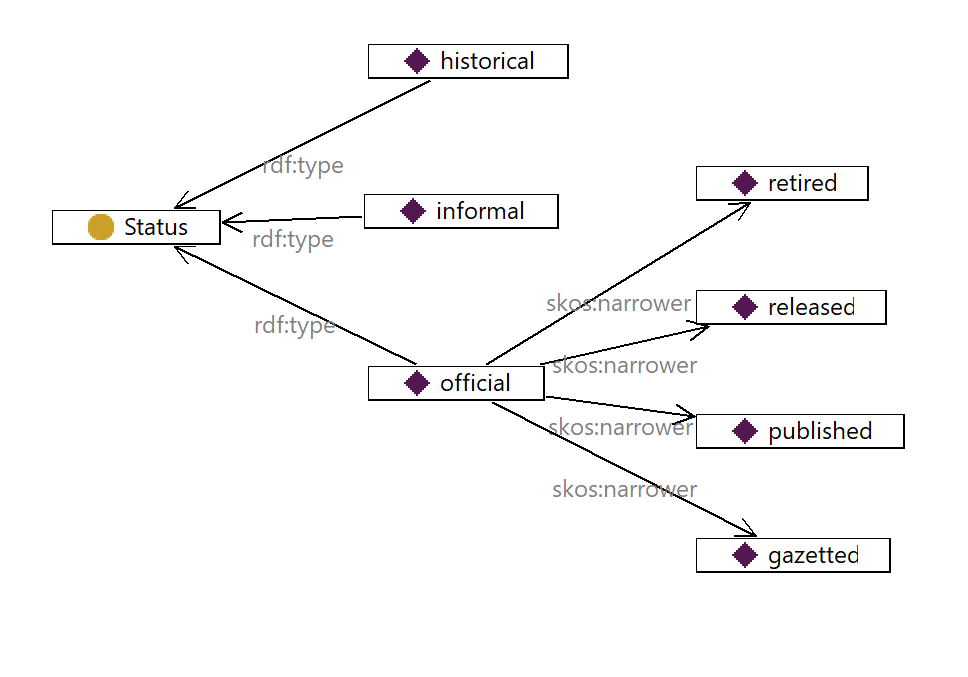
assigned a designated 'status', with default="informal" - denotes a natural or constructed location An **official-place-name** is a **place-name** that also - is authorized by a place-naming-authority, often a jurisidiction (national, state or local government) - is a member item in a gazetteer - has lifecycle information (status, dates) Each individual place-name or official-place-name is associated with one **place**. A **place** is - a location with at least a point geometry - which has a specified classification (inhabited place, administrative area, mountain, school, station, park ...). - with one or more names associated with each individual place. This ontology uses classes and properties from existing vocabularies, in particular - [GeoSPARQL](http://www.opengis.net/ont/geosparql) - [SKOS](http://www.w3.org/2004/02/skos/core) - [Dublin Core](https://www.dublincore.org/specifications/dublin-core/dcmi-terms/)  |
| IRI |
http://linked.data.gov.au/def/placenames.ttl
|
|---|
| IRI |
http://linked.data.gov.au/def/placenames/gazetted
|
|---|
| IRI |
http://linked.data.gov.au/def/placenames/informal
|
|---|
| IRI |
http://linked.data.gov.au/def/placenames/official
|
|---|
| IRI |
http://linked.data.gov.au/def/placenames/published
|
|---|
| IRI |
http://linked.data.gov.au/def/placenames/released
|
|---|
| IRI |
http://linked.data.gov.au/def/placenames/retired
|
|---|
| IRI |
https://orcid.org/0000-0002-3884-3420
|
|---|
| IRI |
https://orcid.org/0000-0002-4643-7289
|
|---|
| IRI |
https://orcid.org/0000-0002-8742-7730
|
|---|
| IRI |
https://orcid.org/0000-0003-3425-0780
|
|---|
http://linked.data.gov.au/def/placenames/http://linked.data.gov.au/def/placenames/http://purl.org/dc/terms/http://linked.data.gov.au/dataset/placename/http://www.opengis.net/ont/geosparql#http://linked.data.gov.au/def/geox#http://linked.data.gov.au/def/loci#http://www.w3.org/2002/07/owl#http://www.w3.org/ns/dx/prof/http://www.w3.org/ns/prov#http://linked.data.gov.au/def/placetype/http://www.w3.org/1999/02/22-rdf-syntax-ns#http://www.w3.org/2000/01/rdf-schema#http://purl.org/linked-data/registry#https://schema.org/http://www.opengis.net/ont/sf#http://www.w3.org/2004/02/skos/core#http://purl.org/vocab/vann/http://www.w3.org/XML/1998/namespacehttp://www.w3.org/2001/XMLSchema#| c | Classes |
| op | Object Properties |
| fp | Functional Properties |
| dp | Data Properties |
| dp | Annotation Properties |
| p | Properties |
| ni | Named Individuals |