Scenario modelling
TCRM can also be used to simulate the wind field from an individual
event. Given the track of a tropical cyclone, users can run the
wind module only, and generate the maximum wind swath from a
TC. The tcevent.py script enables users to efficiently run a
scenario simulation, including performing temporal interpolation of
the track positions to generate a realistic representation of the wind
field. This can be useful for exploring synthetic events in more
detail, or for analysing the wind field from an historical tropical
cyclone.
TCRM does not currently account for local landscape effects on wind speed (e.g. topographic enhancement or changes in surface roughness due to vegetation or built environments). Users should determine the best way to include these effects for their own purposes.
As TCRM uses a parametric profile, the primary vortex is axisymmetric, and asymmetry in the surface winds arises solely due to the forward motion of the cyclone and the (uniform) surface friction. For a complete and accurate representation of the winds from an actual tropical cyclone, the simulated winds from TCRM should be combined with observed maximum wind speeds in the vicinity of the cyclone using spatial interpolation methods (e.g. kriging).
Setting up a scenario
Track file requirements
Simulating an individual event requires details of the track of the
cyclone. As a minimum, a track file must contain the following fields:
index, indicator or tcserialno (to uniquely identify an
event); date/time information (either as a single field, or as
individual components); latitudel; longitude; central pressure and
radius to maximum winds.
The index field (or the alternatives) is required as the software
uses the same methods to read the source data for both individual
events and best-track databases that contain many events. The example
configuration below uses an index field, with 1 in the first
row and 0 in all subsequent rows.
The radius to maximum wind is required in individual events, as it cannot be artificially generated, as is the case in the generation of synthetic events.
Configuration
Users will need to manually edit a configuration file to execute a scenario simulation. Many of the options in the main TCRM configuration file are not required for scenario simulation, so it is recommended to create a reduced configuration file that contains only the required sections and options.
A basic configuration file for a scenario simulation would look like this:
[DataProcess]
InputFile = scenario.csv
Source = NRL
FilterSeasons = False

[WindfieldInterface]
Margin = 3
Resolution = 0.02
profileType = powell
windFieldType = kepert

[Timeseries]
Extract = True
LocationFile = ./input/stationlist.shp
StationID = WMO

[Input]
landmask = input/landmask.nc
mslpfile = MSLP/slp.day.ltm.nc

[Output]
Path = ./output/scenario

[NRL]
Columns = index,skip,skip,date,lat,lon,skip,skip,pressure,rmax
FieldDelimiter = ,
NumberOfHeadingLines = 0
PressureUnits = hPa
SpeedUnits = kts
LengthUnits = km
DateFormat = %Y%m%d %H:%M

[Logging]
LogFile = output/scenario/log/scenario.log
LogLevel = INFO
Verbose = True
NewLog = True
DateStamp = True
Running the scenario
The tcevent.py script loads the track file, performs the temporal
interpolation and then passes the interpolated track file to the
wind module. Since the Region section has been removed, the
wind.run() method will set the grid domain to cover the entire
extent of the track.
Make sure python is in your system path, then from the base
directory, call the tcevent.py script, with the configuration
file option included. For example, to run the example scenario:
python tcevent.py -c example/scenario.ini
If the -v option is included, then all logging messages will be
printed to the console. The level of logging detail is set in the
configuration file.
- Note
tcevent.py cannot be executed in parallel.
Command line arguments
- -c file, --config file
Path to a configuration file.
- -v, --verbose
If given, logging messages will be printed to the console.
- -d, --debug
In the case that execution results in an exception, allow the Python stack to call into the stack trace (through implementation of a custom hook script) and start the Python debugger (
pdb).
Extract time series data
When running a scenario, it is possible to extract a time series of the wind speed and sea level pressure values from the grid at selected locations. The locations are defined in a user-supplied point shape file (a location database is planned for inclusion in future versions to better facilitate this feature). The shape file should contain a field with a unique identifier, otherwise station output is numbered sequentially through the locations.
Locations must be provided in geographic coordinates (longitude, latitude coordinates). No reprojection is performed.
Output is a ‘regional’ wind speed – that is, the wind speed at that location, excluding local topographic or landscape effects. These effects can be incorporated offline (i.e. outside the TCRM framework).
The data is stored in a separate csv file for each location, and data is plotted on a simple figure for visual inspection.
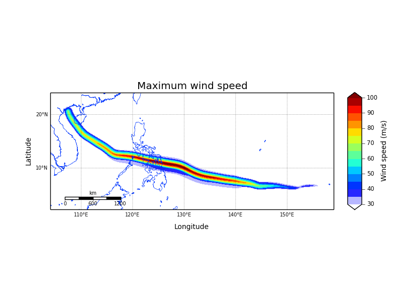
Estimated maximum wind speed swath of Super Typhoon Haiyan (2013) across the Philippine archipelago. This simulation used the best track estimate from the Joint Typhoon Warning Center to establish the intensity and radius to maximum winds of the typhoon. No attempt is made to fit the radial profile to defined wind radii (e.g. radius of 46-, 50- or 34-knots).
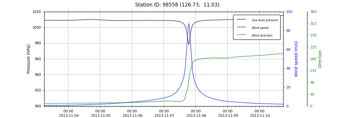
Time series data for Super Typhoon Haiyan at Guiuan, Samar, Philippines.
- Note
The double labels on the secondary (right-hand) y-axis require Matplotlib version 1.3 or later.
Troubleshooting
Some common errors when running a scenario.
MemoryError
In isolated cases, tcevent.py may fail and report a message that
ends with MemoryError. This arises when the size of arrays in
Python exceed 2GB (on 32-bit systems). Conditions that lead to this
error are not clear. To resolve the problem, it is recommended to
reduce the domain of the wind field by adding a Region section to
the configuration file.:
[Region]
gridLimit = {'xMin':118., 'xMax':122., 'yMin':-23., 'yMax':-17.}
This will restrict calculation of the wind field to the defined
domain. The gridLimit value is described in the
Region section.