This training documentation is automatically built in a Github Action and deployed to https://surroundaustralia.github.io/ga-training/training-plan.html - commits to bitbucket will not update the online documentation.
1. Modelling, Ontologies, Dataset and Feature Collection definitions
The FSDF supermodel documentation is in Geoscience Australia’s Github at FSDF Supermodel.
Ontologies, dataset, and feature collection definitions are available in RDF, as turtle, in the Digital Atlas ETL repo. Note the FSDF ontology covers a number of FSDF datasets, which do not require their own ontology.
2. Architecture
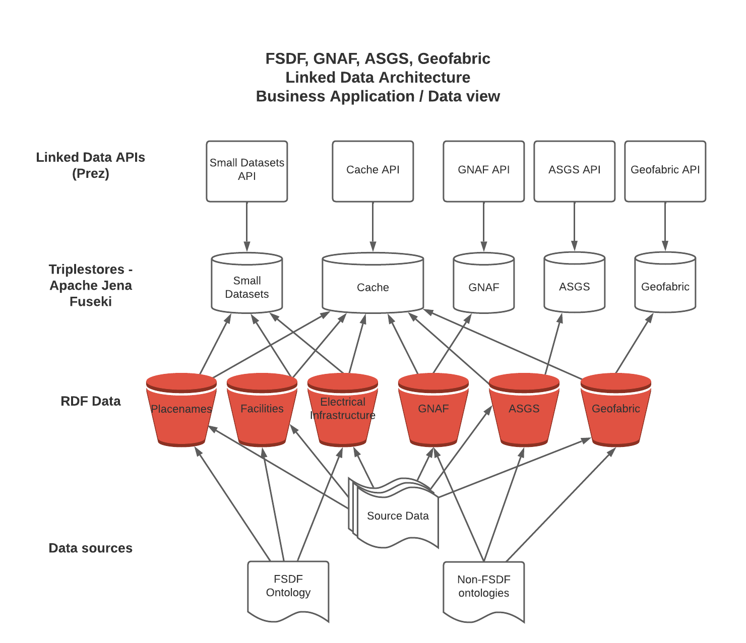
2.1. Application and Data
The following diagram depicts the architecture for data from source to presentation in the various APIs, along with the different configurations currently set up. The source data varies between datasets, and has not been expanded in this diagram. For the Small Datasets, it is a Postgres instance; and for the other datasets it is shapefiles downloaded from government websites, and hosted on S3 buckets.
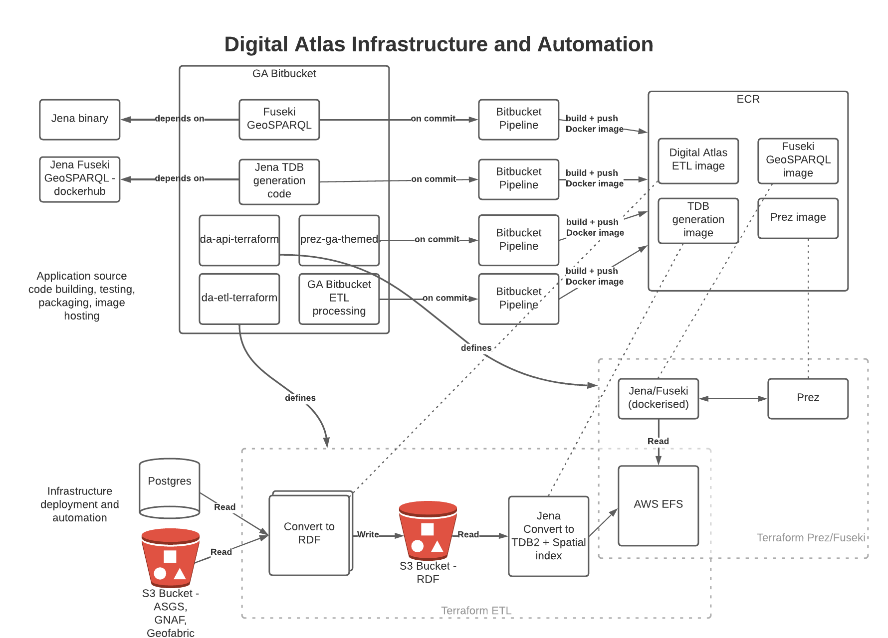
2.2. Infrastructure and Automation
The following diagram depicts the architecture from an infrastructure and automation perspective. The six main code repositories used for the project are shown, along with CI pipelines to build and push images to Amazon Elastic Container Registry. The key infrastructure components are shown on the lower half, with boxes showing the Terraform scripts that define these components. EFS is manually mounted first to the ETL processing, then switched to the API instances.
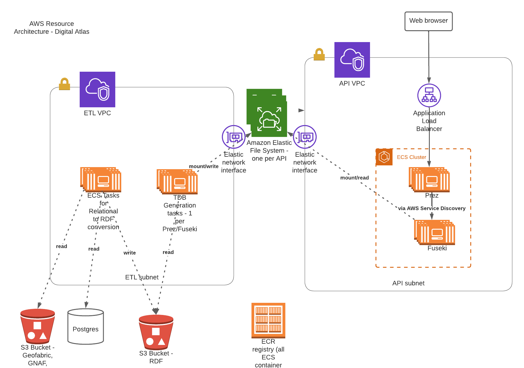
2.3. AWS Resources
The following diagram shows the main AWS resources used to deploy the ETL and API components of the solution.
3. Dataset overview
The tables below summarise the Datasets and Feature Collections in FSDF that have been processed, along with counts of Features within these. GNAF, Geofabric, and ASGS have also been included for context.
3.1. FSDF
| Dataset | Feature Collection | Feature Count |
|---|---|---|
Facilities |
Medical |
7,123 |
Facilities |
Emergency Management |
8,901 |
Facilities |
Education |
26,403 |
Electrical Infrastructure |
Power Substations |
1,101 |
Electrical Infrastructure |
Transmission Lines |
2,461 |
Electrical Infrastructure |
Power Stations |
536 |
Placenames |
Places |
287,338 |
3.2. Other government datasets
| Dataset | Feature Collection | Feature Count |
|---|---|---|
Australian Statistical Geography Standard (ASGS) Edition 3 |
Australia |
2 |
Australian Statistical Geography Standard (ASGS) Edition 3 |
States & Territories |
10 |
Australian Statistical Geography Standard (ASGS) Edition 3 |
Australian Drainage Divisions |
17 |
Australian Statistical Geography Standard (ASGS) Edition 3 |
Greater Capital City Statistical Areas |
35 |
Australian Statistical Geography Standard (ASGS) Edition 3 |
Indigenous Regions |
59 |
Australian Statistical Geography Standard (ASGS) Edition 3 |
Tourism Regions |
76 |
Australian Statistical Geography Standard (ASGS) Edition 3 |
Statistical Areas Level 4 |
108 |
Australian Statistical Geography Standard (ASGS) Edition 3 |
Commonwealth Electoral Division 2021 |
170 |
Australian Statistical Geography Standard (ASGS) Edition 3 |
Statistical Areas Level 3 |
359 |
Australian Statistical Geography Standard (ASGS) Edition 3 |
Indigenous Areas |
431 |
Australian Statistical Geography Standard (ASGS) Edition 3 |
State Electoral Division 2021 |
452 |
Australian Statistical Geography Standard (ASGS) Edition 3 |
Local Government Area 2021 |
566 |
Australian Statistical Geography Standard (ASGS) Edition 3 |
Indigenous Locations |
1,139 |
Australian Statistical Geography Standard (ASGS) Edition 3 |
Statistical Areas Level 2 |
2,473 |
Australian Statistical Geography Standard (ASGS) Edition 3 |
Postal Area |
2,644 |
Australian Statistical Geography Standard (ASGS) Edition 3 |
Destination Zones |
9,329 |
Australian Statistical Geography Standard (ASGS) Edition 3 |
Suburbs and Localities |
15,353 |
Australian Statistical Geography Standard (ASGS) Edition 3 |
Statistical Areas Level 1 |
61,845 |
Australian Statistical Geography Standard (ASGS) Edition 3 |
Mesh Block |
368,286 |
Australian Hydrological Geospatial Fabric |
Drainage Divisions |
13 |
Australian Hydrological Geospatial Fabric |
River Regions |
219 |
Australian Hydrological Geospatial Fabric |
Contracted Catchments |
194,053 |
Geocoded National Address File |
Street Locality |
734,292 |
Geocoded National Address File |
Address Site |
15,411,809 |
Geocoded National Address File |
Addresses |
15,929,362 |
4. ETL processing
4.1. RDF generation
Python based row processing utilising python pandas, SQLAlchemy to connect to postgres. Python’s pandas library provides a good wrapper for ingestion of data from a range of relational sources, including Postgres databases as currently used at GA. It is a widely used well supported library. Once read in to a pandas Dataframe (an in memory table), the data may be iterated over row by row with any data manipulation performed using Python functions; for example built in string functions, and geospatial conversion functions through third party libraries such as Shapely. This provides a high degree of flexibility for any necessary data manipulation, including mapping of codes, logic, spelling corrections etc. which can be difficult or expensive operations with other methods. The Python code is readable for new users, and can easily be updated to suit any new requirements, or fix bugs.
RDFLib is utililsed to create valid RDF from each row of data, this ensures no syntax errors are introduced into the RDF graph. The data is serialised using RDFLib, to a set of RDF files. The exception to this is the GeoFabric and GNAF datasets, for which record by record processing is done from database dumps. This is due to the size of these datasets, which could not be loaded in to memory on most desktop computers.
The ETL scripts are collected in the Digital Atlas ETL repo
4.1.1. Local development, testing
To make updates to the ETL scripts, the python scripts in app/processing/{dataset}_block_convert_to_rdf.py within the Digital Atlas ETL repo should be updated. The changes can then be tested locally by running the python code directly (option 1 below), and inspecting the output. Local integration testing can be performed using Docker Compose, both for the ETL process, and to confirm the output displays correctly in Prez.
Options:
-
Run python script directly, either through the terminal, or an IDE run configuration.
-
Docker container - allows testing of the processing code only
-
Docker Compose - allows testing of the processing code, loading it to Jena Fuseki, and displaying it through Prez. This facilitates rapid iteration over the processing code, allowing issues to be identified and resolved early in the development process. Detailed instructions for these methods of running the ETL process and testing are described in the repository’s Readme.
4.1.2. Cloud based processing
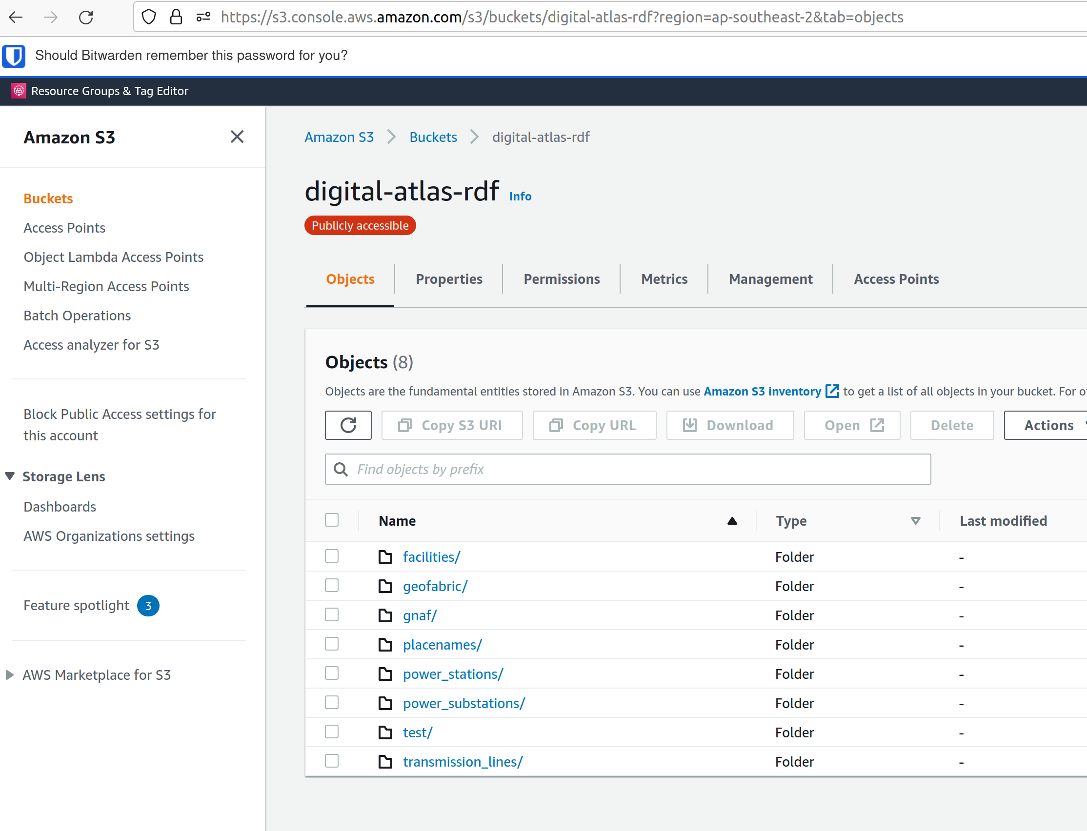
The ETL Process utilises ECS and EFS when deployed in AWS via Terraform, see AWS infrastructure and Infrastructure management below. The Terraform script creates a Task Definition for each dataset to be processed, which can be run manually through the AWS console by navigating to "ECS", and finding the relevant task under "Task Definitions". The tasks are configured to write to the S3 Bucket specified using the "OUTPUT_LOCATION" environment variable. This environment variable is currently set in the task definition JSON template (used for all processing tasks), to s3://digital-atlas-rdf.
The ECS task has permission to write to this bucket through a statement attached to the ecs_task_definition_role_policy_document data definition in data.tf. The processing code will prepend the DATASET environment variable to the key of each object stored in this bucket, effectively creating a 'folder' structure when viewed through the AWS Console. This structure also allows easy pattern matching when attempting to read specific datasets from S3 to process in to TDB2 datasets, as detailed below. The current contents of the bucket are shown below, with all of the RDF data that has been processed by Surround currently in the bucket:
4.2. TDB2 generation and spatial indexing
TDB2 is the second generation on-disk database format utilised by Apache Jena. It provides high scalability, indexation, and works in conjunction with extensions including GeoSPARQL and Full Text Search. TDB2 datasets can be created directly, by utilising the tdb2.tdbloader command line utility packaged with Apache Jena; through the Fuseki UI; or through Assembler files, which are parsed on Jena startup.
4.2.1. Local development, testing
To test "end to end" ETL processing, in a similar manner to as it would occur on AWS, it is recommended to utilise the Docker Compose scripts, as the outputs of one container process can be reused in another. This allows the outputs of the RDF generation steps to be loaded (via a common volume) to the TDB2 generation scripts in a dependent docker container. NB the ETL compose file utilise a Jena image, which includes the tdb2.tdbloader command line utility, but does not include the Fuseki UI.
Should you wish to test RDF that has already been generated, or is from some source other than the RDF generation scripts, you can directly run the Jena Fuseki container image and create a TDB2 dataset through the Fuseki UI, by going to "manage", then "new dataset". NB This TDB2 dataset will not persist beyond the life of the docker container, unless an external mount or volume has been configured, as docker containers are ephemeral.
The Jena spatial index is created through a jar file, repackaged from Apache Jena by Zazuko. This has been added to a multi-stage docker container by Surround, so as to include TDB2 generation along with spatial indexation in one image. This was done as for spatial datasets, the two processes both need to occur, and the output of the TDB2 generation (a TDB2 dataset) is the input of the spatial indexer.
In addition to the TDB2 generation and spatial indexation, a prior step is to validate the input data is valid RDF. For clarity, this validation is to determine whether the files are valid RDF, not whether they conform to any profiles (e.g. the OGC Linked Data API profile), meaning the validation will only provide a guarantee that a TDB2 dataset can be created from them, not that the data itself conforms to any useful model. The validation is completed utilising the Apache Jena RIOT command line utility. Surround has written a short bash script which calls the validator on all nquads files which are to be loaded, and should any of them contain any invalid RDF, prints out the problematic lines and errors, and renames the files with an extension of .error. This renaming prevents tdb2.tdbloader attempting to load them to a TDB2 dataset. Successfully validated files will also write a short message confirming their valid format. Should a file fail validation, you should try to identify the problematic code which generated invalid RDF, fix this, and the invalid RDF files (or parts of them, and apply a patch). The TDB2 dataset can either be appended to by re-running processing on just the problematic files, or the whole TDB2 dataset can be regenerated if this is easier.
4.2.2. Cloud based processing
Task definitions have been created to allow running the TDB2 generation on AWS. This is useful (and arguably necessary) for larger datasets. A task has been created for each TDB2 dataset, which reads data from the relevant RDF Datasets (as RDF files in the output RDF bucket), and writes the output TDB2 dataset to a mounted EFS volume. These are:
| TDB2 Dataset | RDF Datasets (dcat:Dataset) |
|---|---|
cache |
power_substations, power_stations, transmission_lines, facilities, placenames, gnaf, asgs, geofabric |
fsdf |
power_substations, power_stations, transmission_lines, facilities, placenames |
gnaf |
gnaf |
asgs |
asgs |
geofabric |
geofabric |
To run the TDB2 generation task on AWS, the task must specify and EFS volume that can be mounted. Either an existing TDB2 dataset can be used, or a new one must be created. These scenarios are described in detail below:
-
There is an existing TDB2 dataset on an existing EFS volume which you would like to add additional data to. You will need to:
-
Ensure any Jena Fuseki instances currently using the volume are stopped. You can do this by setting the "Desired tasks" count to zero on the relevant "Service" in the
ld-digitalatlas-nonprodcluster on AWS; and -
Remove the network mount points for the EFS volume. Go to the EFS homepage in AWS, select the relevant EFS volume (as it already exists, it should be mapped to the relevant TDB2 dataset in the API Terraform) navigate to network, click edit, and remove the mount points.
-
-
A new TDB2 dataset is required, requiring an EFS volume to be created. You will need to:
-
Go in to the AWS console (or through the CLI or otherwise) and create an EFS volume in the appropriate region (ap-southeast-2); and
-
AWS will automatically generate network mount points, delete these in the console so terraform can create its own network mounts in the right subnets for the task to use. To do this, navigate to network, click edit, and remove the mount points.
-
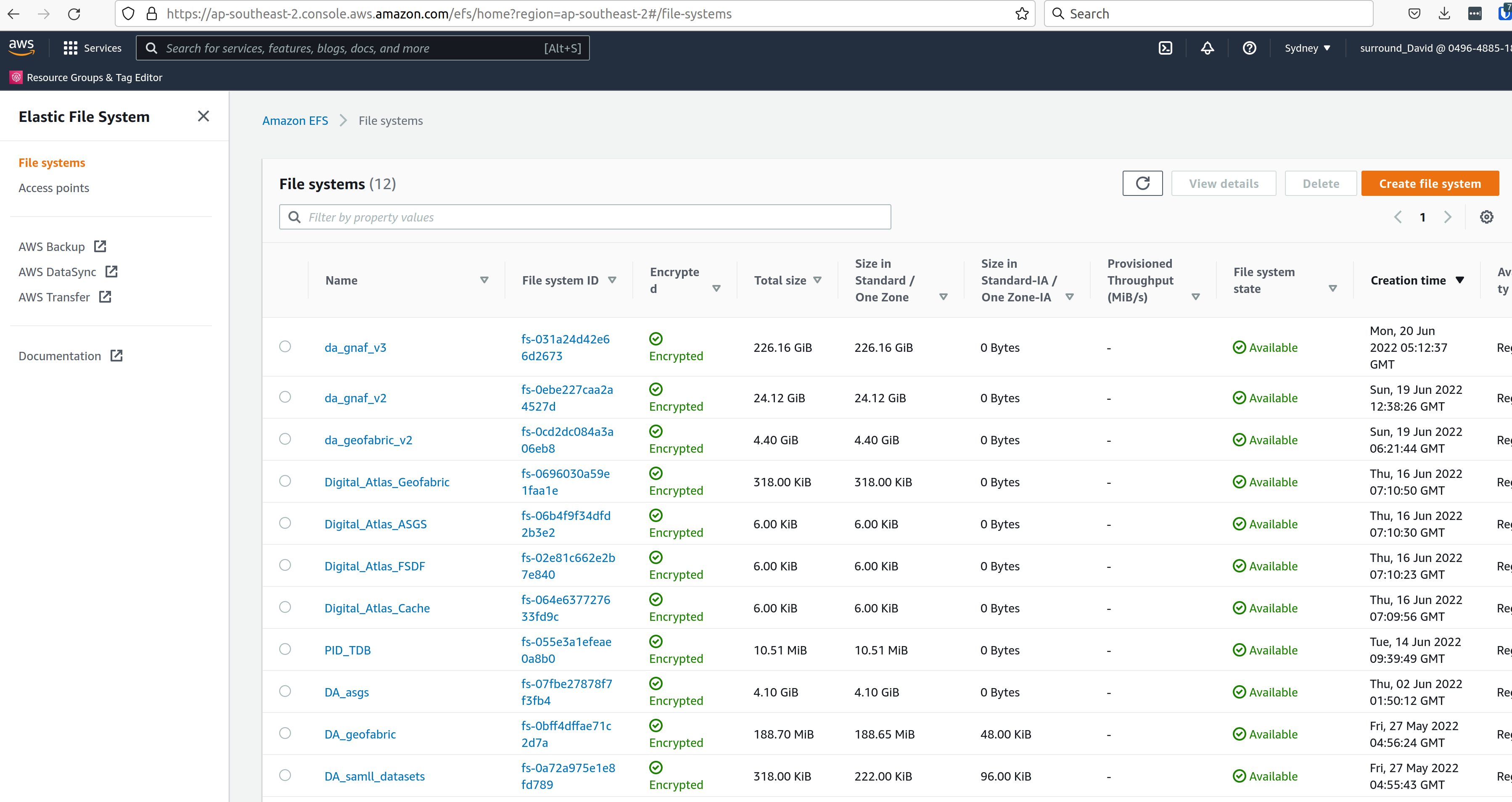
At this point, you should have an EFS volume listed under the EFS File Systems page, as in the screenshot below:
Specify the EFS volume in the da-etl-terraform repository’s terraform.tfvars file, under efs_id. This will set the task up to utilise the appropriate volume when deployed. Run Terraform apply, and wait for the changes to propagate.
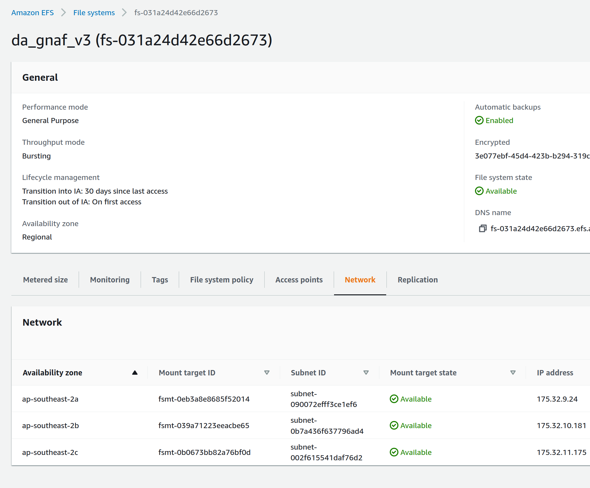
Log in to the AWS console, navigate to EFS, select the relevant EFS volume, and make a note of the Subnet IDs the EFS mount targets are in (under the Network tab), as shown in the screenshot below:
The task can now be run and will mount the correct volume, as specified in Terraform. To run the task, navigate to ECS in the AWS console, click on "Task Definitions", find the relevant task (they are all prepended with "tdb2_generation_*"), select "Deploy" and then "Run task".
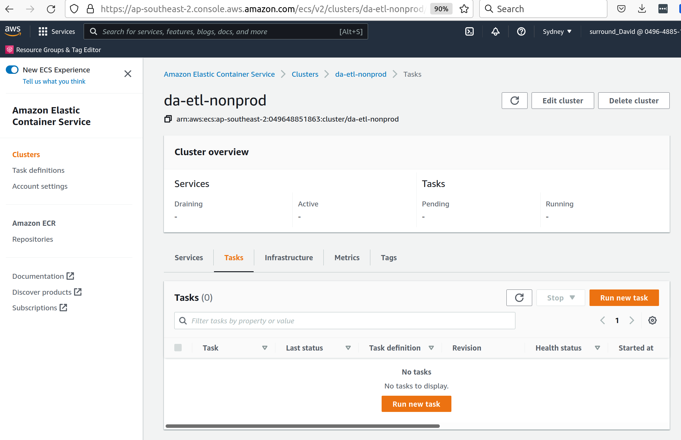
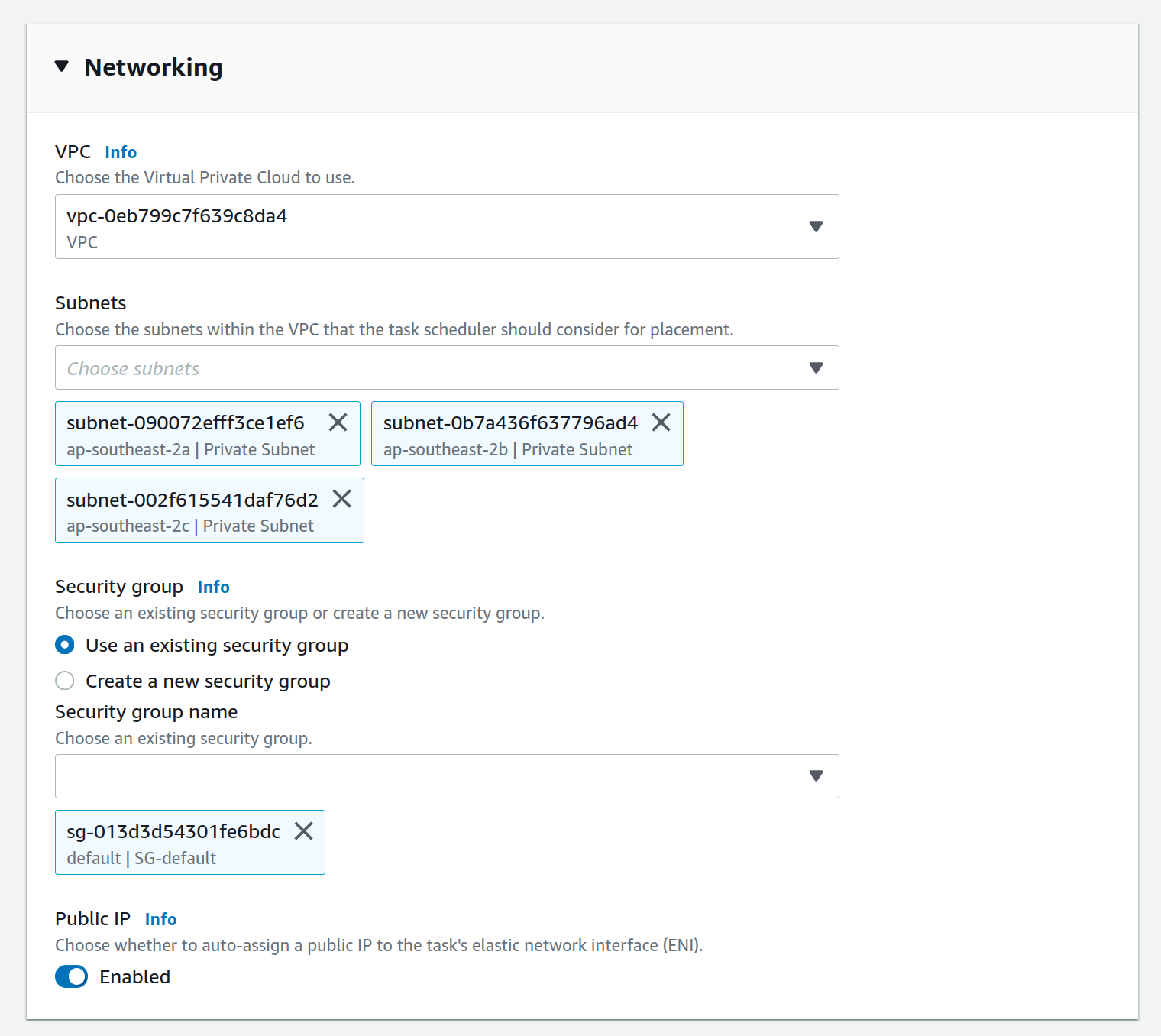
Select the relevant ECS Cluster (currently figured as da-etl-nonprod), and select only the relevant subnets that you made a note of above, as shown in the screenshot below:
To view the status of the task, click on the task ID, and then click on "logs". It can take a minute for the task to be registered/deployed. Once the task has finished, logs will not be available for viewing under the ECS pages, however logs have been configured to be sent to cloudwatch logs, so they can be viewed here until the retention period ends, currently set to 1 day.
4.3. Display of linked data through a web interface
4.3.1. Web application
The linked data API used for display is a Surround built application, Prez, which is based on FastAPI. FastAPI is an asynchronous web framework written in Python. It suits the task of a linked data API well as regular Python code can be used directly in the functions which generate pages, allowing 'on the fly' manipulation of RDF for presentation in different formats, including HTML for the web. Python’s RDFLib library is used for any manipulation of RDF prior to display. Data is retrieved from a backend SPARQL endpoint, which in the case of the systems implemented for Geoscience Australia is provided by a Jena Fuseki instance. Prez is a proprietary product that is licensed under BSD-3.
The data used by Prez, while all RDF, can be classified in to three categories:
-
Instance data. This is the output of the ETL processing, and includes data at the Feature, Feature Collection, and Dataset level.
-
Context data. This includes ontologies for the dataset(s), and any related ontologies needed to understand the data, for example the GeoSPARQL ontology. Prez only requires labels and descriptions from these ontologies; though sometimes the entire ontologies are included, as they are small in size and can provide useful context for direct queries to the SPARQL endpoint.
Prez is available as a docker image on dockerhub, and the source code is available on Github.
4.3.2. Triplestore
-
The triplestore used is a combination of three open source Apache Jena related technologies:
-
Jena (Java triplestore)
-
TDB2 (Persistent store for Jena)
-
Fuseki (Webserver providing UI and SPARQL endpoints)
-
-
Public docker images for Jena and Jena with Fuseki have been created by a Jena user, Stain, and are available on Docker Hub
-
The Jena Fuseki image includes both these components (and the ability to work with TDB2)
-
The Jena image includes a set of TDB2 command line utilities, which can be used to load RDF data to TDB2, and then query/update/delete directly in TDB2. This is the preferred approach for creating large datasets, or performing updates across large numbers of triples.
4.4. Source code management
4.4.1. Processing code (source data to RDF)
The ETL processing code, described in RDF generation, is available in the digital-atlas-etl repository on GA’s BitBucket. This repository includes a bitbucket pipeline script which automatically builds and pushes a docker image to the digital-atlas/etl repository in GA’s AWS Account.
4.4.2. TDB2 generation
A multi-stage build docker image is used to generate TDB2 datasets, including a spatial index, as described in TDB2 generation and spatial indexing. This dockerfile is automatically built in a bitbucket pipeline, and the resulting image pushed to the tdb-generation repository in GA’s AWS Account.
4.4.3. Prez
Surround Australia maintains Prez through a github repository. If there are issues with Prez, or feature suggestions, it is recommended to add these as issues to the issue tracker at https://github.com/surroundaustralia/Prez/issues. A suite of unit tests are maintained, including tests for the different endpoints. A docker image is built for each git tagged version (built with tag 'latest'), and versioned images are built when a release is made in Github. We recommend pinning the production version of Prez you use to a particular version, and performing user acceptance testing on any upgrades to Prez prior to utilising these in production.
At present, the themes (CSS) and static template pages (jinja templates) made specifically for GA are added in to the base Prez docker image provided by Surround, to produce a "themed" version of Prez. This theming represents a minimal Docker script, available in the ga-themed-prez repository. This repository has not yet had the bitbucket pipeline enabled as Surround doesn’t currently have permission to do so
In a future release, it is planned to enable dynamic loading of themes at API startup, configured through an environment variable. This will remove the need to build/maintain a separate themed docker image.
4.4.4. Jena (TDB2 generation, spatial indexation, RDF validation)
Surround has created a docker image which combines the downloading of RDF files from an S3 bucket, RDF validation, TDB2 generation, and Spatial Indexation. This image is in the TDB Generation repository. This repository has not yet had the bitbucket pipeline enabled as Surround doesn’t currently have permission to do so
4.4.5. Jena Fuseki
Jena Fuseki includes both Apache Jena, the triplestore, and Fuseki, the frontend web framework including SPARQL endpoint functionality. The version of Jena Fuseki used includes the GeoSPARQL extension. The image used is based on one provided at Zazuko’s Fuseki GeoSPARQL Github repository. This image simply downloads the relevant Jena binaries and adds them to a docker image. To this image Surround adds a Jena dataset config, and push the resulting image to the fuseki ECR repository.
4.5. Continuous integration and continuous deployment
-
Bitbucket pipelines for application packaging as docker images, and pushing to container registries.
-
Updates to application processing and API code will be automatically built in to new images and available for deployment, however manual deployment is required, in order to facilitate User Acceptance testing prior to deployment. Learning Resources: bitbucket-piplines.yml file at https://bitbucket.org/geoscienceaustralia/digital-atlas-etl/addon/pipelines/home
4.6. AWS infrastructure
A brief description of the AWS resources ECS services and ECS tasks are used to run the docker containers.
-
Elastic Container Service (ECS) - Runs the docker containers as services (for Prez and Jena) or as one off jobs (ETL processing).
-
Elastic File System (EFS) - provides persistent storage for the docker containers running on ECS.
-
Elastic Load Balancer (ELB) - provides load balancing and traffic direction for the ECS services.
-
Elastic Container Registry (ECR) - provides a registry for the docker images used by the ECS services.
-
Simple Storage Service (S3) - For storage of RDF and raw data. Learning resources:
4.7. Infrastructure management
Terraform was used as this is the preferred GA infrastructure management tool. Two git repositories were used to set up separate terraform stacks. One stack was created for ETL, containing "static" task definitions which can be run on demand, and a second for Prez/Fuseki, which defines these as an ECS service, meaning they run continuously as containerised applications on AWS.
These repositories are at:
5. Provenance
A provenance sankey diagram is available at http://sankey-prov-frontend.s3.ap-southeast-2.amazonaws.com/index.html. This provenance application queries a backend Jena Fuseki instance at: http://digital-atlas-lb-1137864764.ap-southeast-2.elb.amazonaws.com:3200/#/. Credentials for the Jena Fuseki instance are provided in the terraform.tfvars file of the da-api-terraform repo.
6. RDF Validation tools
RDF validation tools are available at http://digital-atlas-lb-1137864764.ap-southeast-2.elb.amazonaws.com:9000/validate. This can be used to validate RDF for conformance against different profiles, including a SpacePrez profile, to determine whether a given dataset will display in SpacePrez.