Background
The algorithm used to calculate the BAL is based on Method 1 in the Australian Standard AS 3959 (2009)–**Construction of buildings in bushfire-prone areas**. Method 1 is a simplified procedure that involves five steps to determine BAL, and is subject to limitations on the circumstances in which it can be used.
Warning
This method is not valid where the effective slope under the classified vegetation is more than 20 degrees downslope. Within the BAL toolbox, where the slope is greater than 20 degrees a constant value of 200 is used for the BAL.
Procedure to determine BAL
According to the Standard AS 3959 (2009), the calculation of BAL involves five steps.
Step 1
Select the relevant Fire Danger Index (FDI) based on the locations in Table 2.1 in the Australian Standard AS 3959 (2009). For example, from Table 2.1, the FDI for Western Australia is 80.
| State/region | FDI |
| Australian Capital Territory | 100 |
| New South Wales | |
|
100 |
|
50 |
|
80 |
| Northern Territory | 40 |
| Queensland | 40 |
| South Australia | 80 |
| Tasmania | 50 |
| Victoria | |
|
50 |
|
100 |
| Western Australia | 80 |
Note
The FDI values may be able to be refined within a jurisdiction or region where sufficient climatological data is available and in consultation with the relevant regulatory authority.
Note
The FDI values were provided by the Australasian Fire and Emergency Service Authorities Council (AFAC).
Note
Alpine and sub-alpine areas are defined as per the National Construction Code, Volume 2 [NCCV2].
Step 2
Classify the input vegetation dataset into seven vegetation types defined in Table 2.3 in the Standard AS 3959 (2009). See AS 3959 for indicative illustrations and detailed descriptions of the range of vegetation types.
- 1: Forest,
- 2: Woodland,
- 3: Shrubland,
- 4: Scrub,
- 5: Mallee/Mulga,
- 6: Rainforest,
- 7: Grassland/Tussock moorland.
Where there is more than one vegetation type, the classification should be based on the vegetation type that results in the worst case scenario.
Note
Classified vegetation datasets are likely to be classified according to the predominant vegetation in a grid cell, which is not necessarily the worst case scenario.
The numbers from 1 to 7 are assigned to these vegetation classes respectively for calculating BAL.
Step 3
Calculate the distance between the site of interest, and the classified vegetation. According to AS 3959 (2009), the vegetation is only considered when its distance from the site of interest is less than 100 metres. Within the BAL toolbox, this is done spatially for each grid point located within 100 metres of vegetation.
Step 4
Determine the effective slope (the gradient from each cell) and aspect under the classified vegetation. Here, ‘slope’ refers to the slope under the classified vegetation in relation to the building - not the slope between the vegetation and the building. Where the slope of the land under the vegetation is downhill from the edge nearest the building, this slope is regarded as a downslope that will be further analysed. Otherwise the slope is regarded as an upslope.
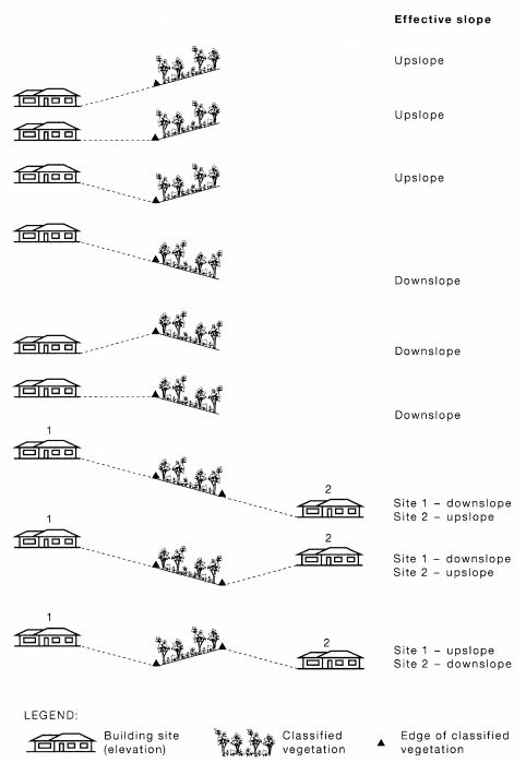
Fig. 1 Determination of effective slope. Figure 2.2 from AS 3959 (2009).
When calculating BAL, upslopes and flat land is treated as a single category. For downslopes, the Standard breaks them down into five classes:
- 0 < downslope <= 5 degrees
- 5 < downslope <= 10 degrees
- 10 < downslope <= 15 degrees
- 15 < downslope <= 20 degrees
- > 20 degrees (beyond consideration of Method 1)
Step 5
Determine the BAL from an appropriate table defined in AS 3959 (2009) based on the input FDI. For example, for Western Australia, the FDI is 80 and thus Table 2.4.3 is adopted for deriving the BAL.
Within the BAL toolbox, these tables are included within the Python code, and are automatically referenced based on the user’s inputs.
Deriving and interpreting BAL
We consider eight cardinal directions: north, northeast, east, southeast, south, southwest, west, and northwest. For each cardinal direction, we consider the neighbouring cells up to 100 metres from the site. We calculate the BAL for each cell surrounding the site based on the neighbouring cell’s:
- vegetation type
- upslope or downslope orientation and grade (slope)
- distance to the site
The calculated BAL falls into one of the following categories: 12.5, 19, 29, 40 or 100, where 100 represents Fire Zone (FZ).
Note
Where the downslope is greater than 20 degrees and there is vegetation, a constant value of 200 is given to the BAL.
The maximum BAL is selected among all neighbouring cells in a given cardinal direction to represent the BAL for that direction.
The final BAL for the site of interest is determined by selecting the maximum BAL from all eight cardinal directions.
The final BAL values correspond to a predicted level of exposure during a bushfire, and are associated with an accompanying construction code.
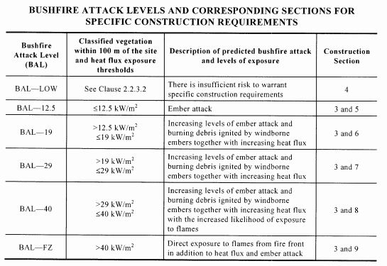
Fig. 2 BAL and corresponding exposure and construction codes. Table 3.1 from AS 3959 (2009).
| [NCCV2] | National Construction Code, Volume 2. http://www.abcb.gov.au/Resources/Publications/NCC/NCC-2016-Volume-Two |