Running the tool
To calculate the BAL, we use the BAL calculation tool within the BAL toolbox installed in ArcGIS 10.2.
Select the BAL calculation tool within the BAL toolbox, see Fig. 7.
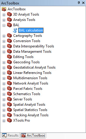
Fig. 7 Select the tool BAL calculation.
Then the BAL calculation window is open, see Fig. 8.
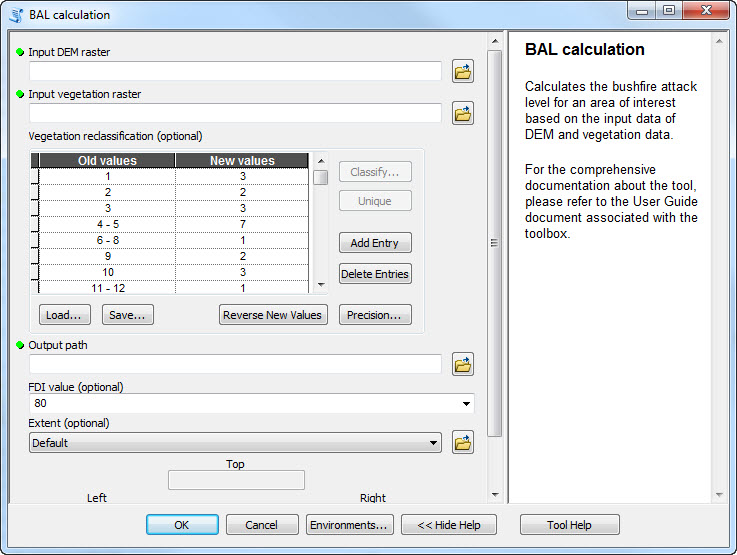
Fig. 8 The BAL calculation window.
Parameters within the tool
Input DEM raster:
Open your input DEM file from a specific location. The DEM must be in a projected coordinate system with linear unit metre. For example GDA94 / MGA zone 50 is a projected spatial reference system and is suitable for use in the western part of Western Australia. More information about GDA94 / MGA zone 50 can be found here.
Input vegetation raster:
Open your input vegetation dataset from a specific location. The vegetation dataset can be in either a geographical or a projected coordinate system. It will be reprojected to the same projection and same resolution as DEM by the BAL tool.
Vegetation reclassification:
Reclassify the input vegetation classes into those defined in the Australian Standard AS 3959 (2009). There are seven classes defined in the Standard. In this tool, we give each class a unique number, i.e.:
- 1: Forest,
- 2: Woodland,
- 3: Shrubland,
- 4: Scrub,
- 5: Mallee/Mulga,
- 6: Rainforest,
- 7: Grassland/Tussock moorland.
The reclassification process needs to be considered by the user, and will vary according to the input vegetation dataset.
A sample reclassification map is entered for the example data. The reclassification map needs to be changed by the users according to their own input vegetation data.
Output path:
Define the output location. Note that this is asking for a folder to write the output to, not a file name.
FDI value:
The input Fire Danger Index (FDI) value has four choices (100, 80, 50, 40) based on the locations, which are specified in AS 3959–2009.
- 100: Australian Capital Territory (ACT), part of New South Wales (NSW) (Greater Hunter, Greater Sydney, Illawarra/Shoalhaven, Far South Coast and Southern Ranges fire weather districts), and Victoria general (excluding alpine areas).
- 80: NSW general (excluding alpine areas, and the areas with FDI 100), South Australia (SA), and Western Australia (WA).
- 50: NSW alpine areas, Tasmania, and Victoria alpine areas.
- 40: Northern Territory (NT), and Queensland (Qld).
Extent:
The extent is used to select the area of interest for which the BAL will be calculated. The default output data extent will be where you have consistent coverage of DEM and vegetation data within the area of interest.
Note
There is a limitation in raster file name length and file path length in ArcGIS. For a raster name in ESRI Grid format, the maximum number of characters is 13 and for full path name, the maximum number of character is 128. For more information, click here. In addition, as tested, each folder name’s length should be restricted to at most eight characters.