What is the Bushfire Attack Level
The Bushfire Attack Level measures the severity of a building’s potential exposure to ember attack, radiant heat and direct flame contact. It is intended to improve the resistance of buildings to bushfire attack from burning embers, radiant heat, flame contact or a combination of these. It applies to buildings sited in designated bushfire-prone areas, as defined in the National Construction Code, Volume 2 [NCCV2].
By improving the ability of buildings in bushfire-prone areas to withstand attack from bushfire, there is an increase in the protection afforded to building occupants (until the fire front passes) as well as to the building itself.
However, improving the design and construction of buildings is only one way that property owners can address the damage caused by bushfire. Other measures fall within the areas of planning, subdivision, siting, landscaping and maintenance.
Note
It should be borne in mind that the measures contained in this Standard cannot guarantee that a building will survive a bushfire event on every occasion. This is substantially due to the degree of vegetation management, the unpredictable nature and behaviour of fire, and extreme weather conditions (AS 3959–2009).
The bushfire attack level is a measure of the severity of a building’s potential exposure to ember attack, radiant heat and direct flame contact, using increments of radiant heat expressed in kilowatts per metre squared. When calculated, the Bushfire Attack Level Toolbox toolbox provides classified levels:
- BAL–LOW
- BAL–12.5
- BAL–19
- BAL–29
- BAL–40
- BAL–FZ
Appendix G in AS 3959–2009 describes the threats associated with each BAL.
How do we determine BAL
The Bushfire Attack Level Toolbox toolbox applies Method 1 from AS 3959–2009 to determine the BAL. Method 1 is a simplified procedure to determine the BAL, which involves five steps. This method is subject to limitations on the circumstances in which it can be used.
Warning
This method is not valid where the effective slope under the classified vegetation is more than 20 degrees downslope. Within the BAL toolbox, where the slope is greater than 20 degrees, a constant value of 200 is assigned to the BAL.
There are five steps in determining the BAL based on method 1 in AS 3959–2009.
Step 1: Determine the relevant FDI
Step 2: Determine the classified vegetation type(s)
Step 3: Determine the distance of the site from the classified vegetation type(s)
Step 4: Determine the effective slope(s) under the classified vegetation type(s)
Step 5: Determine the BAL from the appropriate table
Note
AS 3959-2009 includes a sixth step, which refers to construction requirements. This is not of interest in the BAL toolbox, so is omitted here.
The following sections provide details on determining the BAL, using Bushfire Attack Level Toolbox.
Determine relevant FDI
The relevant Fire Danger Index (FDI) is based on Table 2.1 from AS 3959–2009, for each jurisdiction or region within a jurisdiction. The FDI is an indication of the chance of a fire starting, its rate of spread, intensity and the difficulty of suppresion based on the combination of air temperature, relative humidity, wind speed and both long- and short-term drought effects. The FDI used in AS 3959–2009 refers to the Forest Fire Danger Index calculated by the McArthur Mk 5 Forest Fire Danger Meter using the equations published by Noble et al. (1980) [1].
| State/region | FDI |
| Australian Capital Territory | 100 |
| New South Wales | |
|
100 |
|
50 |
|
80 |
| Northern Territory | 40 |
| Queensland | 40 |
| South Australia | 80 |
| Tasmania | 50 |
| Victoria | |
|
50 |
|
100 |
| Western Australia | 80 |
Note
The FDI values may be able to be refined within a jurisdiction or region where sufficient climatological data is available and in consultation with the relevant regulatory authority.
Note
The FDI values were provided by the Australasian Fire and Emergency Service Authorities Council (AFAC).
Note
Alpine and sub-alpine areas are defined as per the National Construction Code, Volume 2 [NCCV2].
Vegetation classification
The vegetation of the site is classified in accordance with the guidance provided in Table 2.3 and the corresponding figures in AS 3959–2009. Where there is more than one vegetation type, each vegetation type is classified separately with the worst case scenario applied. For example, if there is a mix of grassland and shrubland, then the vegetation would be classified as shrubland, as this results in a higher BAL.
Note
The predominant vegetation type of a site may not necessarily be the worst case scenario.
In general, the land cover datasets often only present the predominant vegetation type. Therefore, we cannot always determine the “worst case” value of BAL. This could also be determined by validation on the ground.
AS 3959–2009 provides a list of exclusions for low threat vegetation and non-vegetated areas, where the BAL is classified as LOW. This includes vegetation greater than 100 metres from the site, small (< 1 ha) areas of vegetation that are also more than 100 metres from other vegetation and low threat vegetation that includes grassland managed in minimal fuel conditions. This includes lawns, golf courses, orchards and cultivated gardens, amongst others. Non-vegetated areas include waterways, roads, buildings, footpaths and rocky outcrops.
Table 2.3 in AS 3959–2009 sets out seven major vegetation classifications:
* Forest
* Woodland
* Shrubland
* Scrub
* Mallee/mulga
* Rainforest
* Grassland
Each of these major vegetation classifications has between one and eleven types, each of which has an indicative figure in the Standard. See Figures 2.3 and 2.4(A) to 2.4(G) in the Standard for these figures. There is also a brief text description of the vegetation types (height, foliage cover, habit, etc.).
Note
Overstoreys of open woodland, low open woodland, tall open shrubland and low open shrubland should be classified to the vegetation type on the basis of their understoreys; others to be classified on the basis of their overstoreys.
Distance to vegetation
The distance to/from the site to the classified vegetation is measured in the horizontal plane.
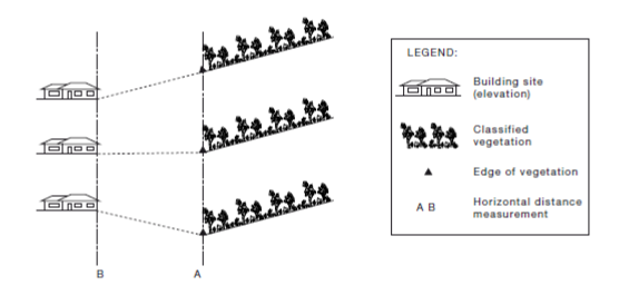
Fig. 15 Determination of distance from site from classified vegetation. The measurement is the horizontal distance, from Point A to Point B. From AS 3959–2009.
In the above figure, the distance from the classified vegetation to the site is the same in all three cases, irrespective of the slope over the intervening distance. In Bushfire Attack Level Toolbox, the effective distance is measured betwen the centre of grid cells of the input raster elevation data.
Effective slope under the classified vegetation
In determining BAL, ‘slope’ refers to the slope under the vegetation in relation to the building. It is not the slope between the vegetation and the site. The slope of the land under the classified vegetation has a direct influence on the rate of fire spread, the severity of the fire and the ultimate level of radiant heat flux.
The definition of upslope and downslope is the definition of the slope, relative to the site being evaluated. If the slope of the land under the classified vegetation is downhill from the edge of the classified vegetation nearest the site, then the slope is considered downslope. If the slope of the land under the classified vegetation is uphill from the edge of the classified vegetation nearest the site, then the slope is considered upslope.
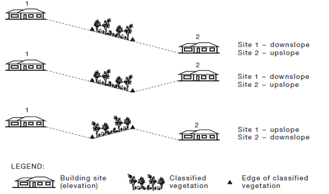
Fig. 16 Determination of effective upslope and downslope. From AS 3959–2009.
Determine BAL from appropriate table
AS 3959-2009 provides a set of lookup tables, from which we can determine the BAL based on a combination of the FDI, distance from classified vegetation and effective slope.
| [NCCV2] | (1, 2) National Construction Code, Volume 2. http://www.abcb.gov.au/Resources/Publications/NCC/NCC-2016-Volume-Two |
| [1] | Noble, I. R., G. A. V. Bary and A. M. Gill (1980): McArthur’s fire-danger meters expressed as equations. Australian Journal of Ecology, 5, pp 201–203, DOI:10.1111/j.1442-9993.1980.tb01243.x |